Abandoned Communities ..... Milton
In 1752 Milton was bought by Joseph Damer. Joseph Damer had inherited a large fortune from a great uncle who had accumulated large tracts of property in Ireland. He acquired a string of titles during the course of his life, finally becoming Earl of Dorchester and Viscount Milton in 1792, but I prefer to go on referring to him as Joseph Damer.
The estate bought by Joseph Damer included the town, the abbey church, still used as the local church by people living in Milton, and the house previously occupied by the monks. Damer decided to convert the estate, with plans that included the demolition of the town and the creation of an artificial lake that would cover much of its area. In the event the amount of water in the stream flowing down the valley was found to be inadequate for a lake of the size Damer had in mind, and as a result a smaller lake was constructed to the south of the town. The town itself was, however, obliterated.
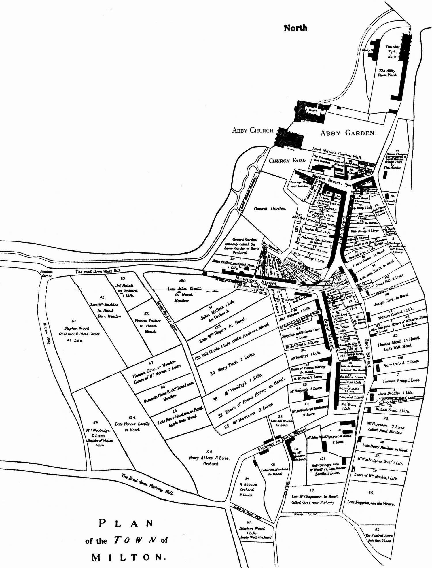
An excellent impression of the town of Milton in the eighteenth century can be gained from a map produced for Joseph Damer in 1769. Copies of the map can be seen today in the abbey church and in the entrance to St James Church in Milton Abbas, the village built to accommodate some of the people from the town.
The map can also be seen in a booklet entitled Milton Abbas, Dorset, by Christopher Fookes, 8th edition published in 2004.
As the map shows, the abbey church and the main house lay near the northern end of the estate. The town lay to the south, being separated by a wall from the area occupied by Damer. A short distance south of the wall Market Street ran east-west, ending in the vicarage and churchyard at its western end. On Market Street were the George Inn, almshouses intended to provide accommodation for six widows, the King's Arms Inn, and the Grammar School. At the widest point of Market Street was a superb market cross. High Street, containing shops, houses, and the Red Lion, ran south from the market cross. Back Street diverged from it and ran down to the southern edge of the town. At the bottom of High Street Newport Street ran to the west, and Broad Street to the south, both lined with more shops and houses. Several more minor thoroughfares are drawn on the map, and there are five or six roads leading out of Milton in various directions.
For Joseph Damer the significance of the map was its depiction of every property within the town, together with the name of each tenant. A minority of the properties are shown as being "in hand". In other words, an agreement had been reached with the tenant that would allow Damer to take possession of the property. All other properties are represented as having one or more "lives". A place that had, for example, two lives, had two people living there who could not be evicted unless a special deal was done with them.
The estate bought by Joseph Damer included the town, the abbey church, still used as the local church by people living in Milton, and the house previously occupied by the monks. Damer decided to convert the estate, with plans that included the demolition of the town and the creation of an artificial lake that would cover much of its area. In the event the amount of water in the stream flowing down the valley was found to be inadequate for a lake of the size Damer had in mind, and as a result a smaller lake was constructed to the south of the town. The town itself was, however, obliterated.
An excellent impression of the town of Milton in the eighteenth century can be gained from a map produced for Joseph Damer in 1769. Copies of the map can be seen today in the abbey church and in the entrance to St James Church in Milton Abbas, the village built to accommodate some of the people from the town.
The map can also be seen in a booklet entitled Milton Abbas, Dorset, by Christopher Fookes, 8th edition published in 2004.
As the map shows, the abbey church and the main house lay near the northern end of the estate. The town lay to the south, being separated by a wall from the area occupied by Damer. A short distance south of the wall Market Street ran east-
For Joseph Damer the significance of the map was its depiction of every property within the town, together with the name of each tenant. A minority of the properties are shown as being "in hand". In other words, an agreement had been reached with the tenant that would allow Damer to take possession of the property. All other properties are represented as having one or more "lives". A place that had, for example, two lives, had two people living there who could not be evicted unless a special deal was done with them.
Two

Grass cutting in progress close to the site of Market Street
Milton in 1769