Abandoned Communities ..... Shropshire
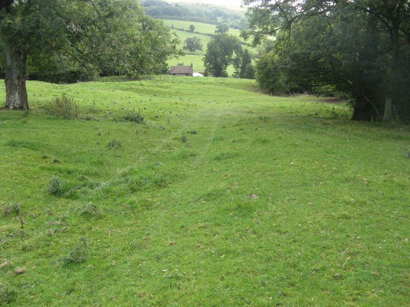
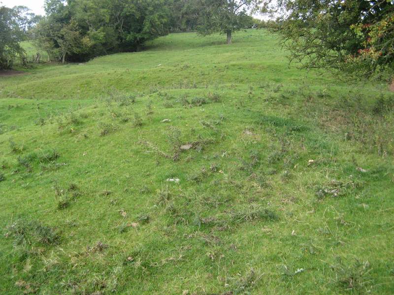
A mile and a half north east of Heath lay the village of Abdon. There is still a place called Abdon, but it now consists of a small number of scattered farms and houses. The medieval village lay on the hillside east of the surviving church. The ground falls from about 270 metres above sea level at the upper end of the site to 250 metres at the lower end. A holloway runs down part of the hillside, and several house platforms can be seen beside it. On the eastern side of the field a deep and wide holloway used to carry traffic that passed through Abdon on its way from Ditton Priors to Clee St Margaret.
The landowners of medieval Abdon are well documented. The list supplied in the Victoria County History includes Wulfwine, Azor Bigot, Shrewsbury abbey, John le Strange, and Geoffrey of Ledwich.
The church at Abdon, dedicated to St Margaret, was in existence by 1138, when Aelfric gave it to Shrewsbury abbey to compensate for having wronged the monks. A lot of it was rebuilt, using the old materials, in the eighteenth century after it was described as being very ruinous. A document of 1662 records that the rector ran a school.
Archaeological investigations have been carried out at Abdon by Trevor Rowley. They provide information about two of the buildings on the site and also indicate that the village seems to have been deserted on two separate occasions.
The first excavation, completed in 1966, revealed a medieval longhouse. It is shown as Site 1 on the plan on the left. The size and position of the building suggest that it may have been the main house in the village. At the eastern end it had a room about 14 by 13 feet, apparently added during a second phase of building. This room was interpreted by Rowley as a solar, that is the sleeping area. In one corner of this room a pit, three feet deep, had been dug, presumably a storage space. The main section of the house, 30 by 12 feet, comprised two rooms. Next to the solar, and joined to it by a doorway, was the main living room, containing a hearth in the centre of the room. The southern wall of this room, four feet wide, was much thicker than any other part of the house. The room at the western end of the house was interpreted as an animal or storage quarter. Another room, marked as a store on the plan on the left, lay outside the solar, but without an internal connection to it.
Objects found at the site included a large quantity of pottery. Sherds of twelfth and thirteenth century cooking pots included fragments from about 40 types of cooking pot rims, many not previously found in Shropshire. It was possible to reconstruct several complete pot rims and the base of a tripod pitcher. Some of the jug handles also belonged to types not before found in the county, including one type also discovered in Warwickshire. As much of the pottery was made from clay identical to that found locally it was inferred that a pottery kiln must have existed nearby.
Iron items among the finds included domestic knife handles, horse shoes, nails, and staples.
The date of the pottery found at the site of the longhouse indicates that it was abandoned around 1300. Presumably Abdon suffered from the same adverse climate changes and disease among cattle experienced at Cold Weston and Heath.
This excavation was reported in T Rowley, Excavations at Abdon Deserted Village, Shropshire Newsletter, November 1966, 1-2.
In 1969 Trevor Rowley conducted a more limited investigation at a site further down the hillside. A stone building with three sections was revealed. It had two rooms either side of a central area that had an entrance on each side. The building was thought not to be a dwelling, but perhaps served as a cow shed or milking area. However, a good deal of pottery from the seventeenth and eighteenth centuries was discovered, indicating that at least part of the village was re-occupied during that time.
T Rowley, Excavations at Abdon, Salop, 1969, Shropshire Newsletter, December 1969, 25.
The people living in Abdon during the later phase of occupation may have been employed in the mines and quarries of Brown Clee. But by the end of the eighteenth century the village was abandoned for the second time. After a visit to Abdon in 1793 Archdeacon Plymley wrote that some houses there had been taken down and several seemed to have fallen down.
If you are considering a visit to the deserted villages described in this section Google Maps will help you find your way from one village to another. I would suggest that you begin by entering Abdon Shropshire. The aerial views that come with Google Maps will give you a good impression of the area around each village and views of some of the more prominent earthworks.
The landowners of medieval Abdon are well documented. The list supplied in the Victoria County History includes Wulfwine, Azor Bigot, Shrewsbury abbey, John le Strange, and Geoffrey of Ledwich.
The church at Abdon, dedicated to St Margaret, was in existence by 1138, when Aelfric gave it to Shrewsbury abbey to compensate for having wronged the monks. A lot of it was rebuilt, using the old materials, in the eighteenth century after it was described as being very ruinous. A document of 1662 records that the rector ran a school.
Archaeological investigations have been carried out at Abdon by Trevor Rowley. They provide information about two of the buildings on the site and also indicate that the village seems to have been deserted on two separate occasions.
The first excavation, completed in 1966, revealed a medieval longhouse. It is shown as Site 1 on the plan on the left. The size and position of the building suggest that it may have been the main house in the village. At the eastern end it had a room about 14 by 13 feet, apparently added during a second phase of building. This room was interpreted by Rowley as a solar, that is the sleeping area. In one corner of this room a pit, three feet deep, had been dug, presumably a storage space. The main section of the house, 30 by 12 feet, comprised two rooms. Next to the solar, and joined to it by a doorway, was the main living room, containing a hearth in the centre of the room. The southern wall of this room, four feet wide, was much thicker than any other part of the house. The room at the western end of the house was interpreted as an animal or storage quarter. Another room, marked as a store on the plan on the left, lay outside the solar, but without an internal connection to it.
Objects found at the site included a large quantity of pottery. Sherds of twelfth and thirteenth century cooking pots included fragments from about 40 types of cooking pot rims, many not previously found in Shropshire. It was possible to reconstruct several complete pot rims and the base of a tripod pitcher. Some of the jug handles also belonged to types not before found in the county, including one type also discovered in Warwickshire. As much of the pottery was made from clay identical to that found locally it was inferred that a pottery kiln must have existed nearby.
Iron items among the finds included domestic knife handles, horse shoes, nails, and staples.
The date of the pottery found at the site of the longhouse indicates that it was abandoned around 1300. Presumably Abdon suffered from the same adverse climate changes and disease among cattle experienced at Cold Weston and Heath.
This excavation was reported in T Rowley, Excavations at Abdon Deserted Village, Shropshire Newsletter, November 1966, 1-
In 1969 Trevor Rowley conducted a more limited investigation at a site further down the hillside. A stone building with three sections was revealed. It had two rooms either side of a central area that had an entrance on each side. The building was thought not to be a dwelling, but perhaps served as a cow shed or milking area. However, a good deal of pottery from the seventeenth and eighteenth centuries was discovered, indicating that at least part of the village was re-
T Rowley, Excavations at Abdon, Salop, 1969, Shropshire Newsletter, December 1969, 25.
The people living in Abdon during the later phase of occupation may have been employed in the mines and quarries of Brown Clee. But by the end of the eighteenth century the village was abandoned for the second time. After a visit to Abdon in 1793 Archdeacon Plymley wrote that some houses there had been taken down and several seemed to have fallen down.
If you are considering a visit to the deserted villages described in this section Google Maps will help you find your way from one village to another. I would suggest that you begin by entering Abdon Shropshire. The aerial views that come with Google Maps will give you a good impression of the area around each village and views of some of the more prominent earthworks.
Four
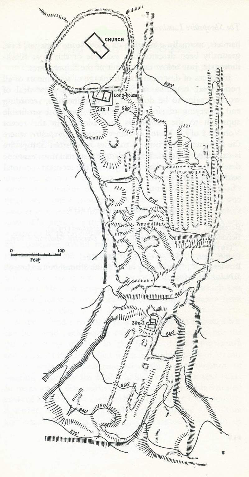
Plan of Abdon village (taken from Trevor Rowley, The Shropshire Landscape, Hodder and Stoughton, 1972)
Earthworks at Abdon, looking down the hill towards the south east.
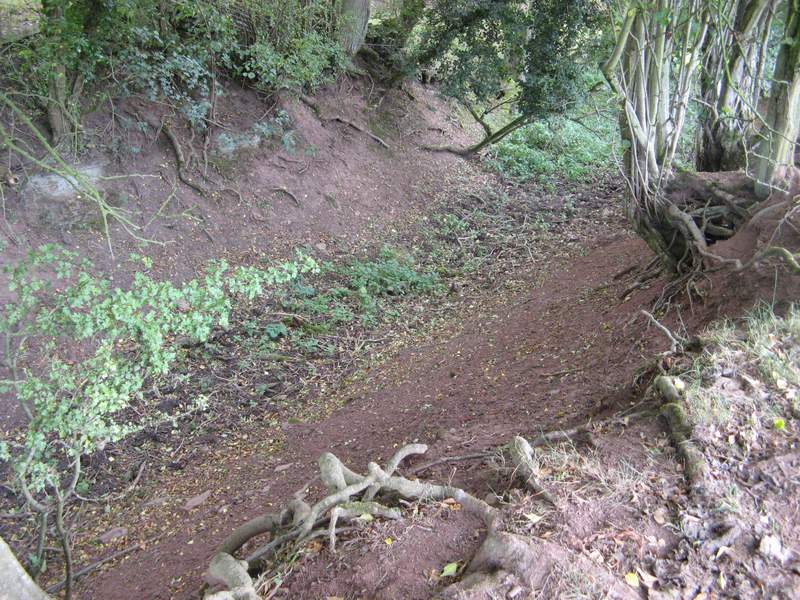
The old road to Ditton Priors
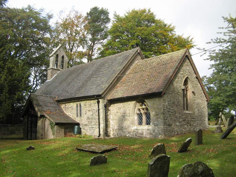
The Church of St Margaret
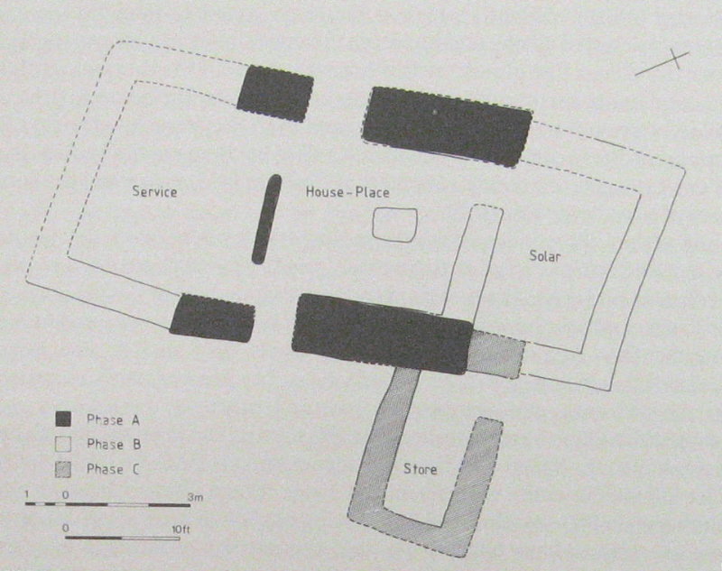
Plan of the longhouse
Site of the seventeenth century building, looking up the slope.
There is still quite a lot going on at Abdon church