Abandoned Communities ..... Stowe
In 1640 Peter Temple initiated court action against Abel Dayrell. The case appears to have dragged on for two years and then ended in a stalemate. By this time, however, the dispute had become more violent. On 25 August 1641 Arthur East, Temple’s gamekeeper, encountered two of Abel Dayrell’s sons and two other men as they entered the park during the night carrying swords and bucklers and long pikestaves, about five yards long. A colleague heard hallowing, shouting, or crying out, and then discovered East lying sore wounded, cut, beat, and bruised.
Dan Beaver’s article has more on this incident and a number of later incidents. Although Arthur East appears to have been quite badly injured on this occasion, Beaver points out that most encounters involved threats, boasts, and the display of arms, yet they generally stopped short of serious violence. On 24 May 1642, for example, Arthur East was spotted by Peter Dayrell and a group of relatives and servants. Peter Dayrell caught hold of East and shook him, and, holding his staff over his head, called him rogue, rascal, thief, and perjured knave, and otherwise threatened to beat him sore. But his cousin Peter Farren, fearing some harm might ensue, dismounted, and took Dayrell in his arms and held him. “Cousin, let the keeper go,” he urged, “you shall not beat him, for he gives you no bad words.” Dayrell replied “Though you will not let me strike him, yet I will hold and shake him.”
The development of their estate by the Temple family did not just upset their neighbours. It would have had profound consequences for the people living on the estate, especially in the village of Stowe. All tenants with holdings in the open fields or rights to use common land were affected by the enclosure of the deer park, by the damage caused by deer or excessive numbers of cattle grazing in the woods and open pasture, and by the enclosure in 1649 by Peter Temple of part of the open fields. In the circumstances some inhabitants may have taken the decision to move away, but in addition there is evidence that the Temple family actively removed people and destroyed their homes. Early in 1642 the Dayrell family and their supporters presented a petition to parliament protesting about the enclosures and other actions undertaken by Peter Temple and requesting that the enclosed land should be opened again. The petition is admittedly not the work of an impartial observer, but it asserts that over the preceding sixteen years Temple had depopulated ten or twelve ancient farms in Stowe, where the farmers had formerly lived very well, maintaining tillage, until he had turned them out with diverse other poor people, to the heavy burden of the neighbourhood.
Some of the people of Stowe, especially those employed by the Temple family, may have been given alternative accommodation, probably in the village of Dadford. Others, especially the “poor people” mentioned in the 1642 petition, were probably obliged to leave the area and seek a new home elsewhere. One option for some of the men would have been to join the armed forces on one side or the other of the Civil War after it began in 1642. Women may have been able to go into domestic service on other estates.
We do not know precisely when the last people left the village of Stowe. Estate maps from about 1680 show the location of the grand new house built by Richard Temple, who inherited the estate from Peter Temple in 1653. They show outbuildings such as stables and barns, and the formal gardens that were laid out on the south side of the house. But the only earlier building depicted on these maps is the church. No dwellings appear.
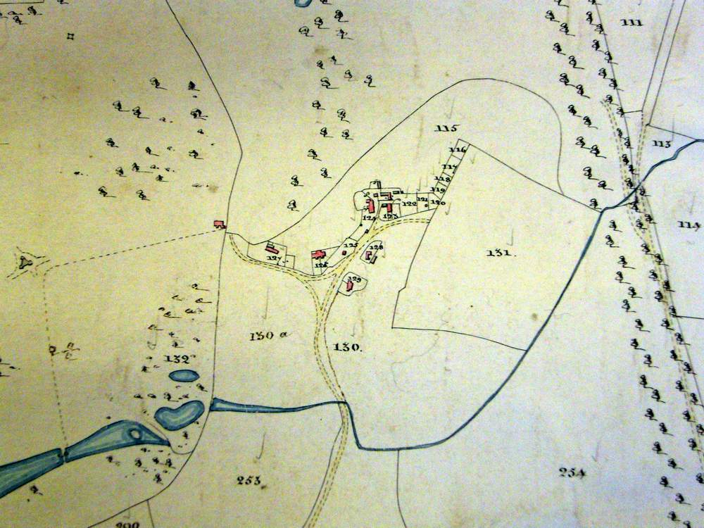
The villages of Boycott and Lamport were abandoned later. The houses of Boycott were probably removed by the second Richard Temple, later Lord Cobham, soon after he acquired the Boycott estate around 1720. At that time Lamport was still in existence, as it is shown, with about a dozen houses, on a survey plan published by Sarah Bridgeman in 1739. It still existed a century later, appearing on a Tithe Apportionment map in 1850. I do not know when it was removed.
These two maps have few common features. Presumably the Tithe Apportionment map can be regarded as more accurate. I am grateful to Laurence Gibson for drawing my attention to it.
Dan Beaver’s article has more on this incident and a number of later incidents. Although Arthur East appears to have been quite badly injured on this occasion, Beaver points out that most encounters involved threats, boasts, and the display of arms, yet they generally stopped short of serious violence. On 24 May 1642, for example, Arthur East was spotted by Peter Dayrell and a group of relatives and servants. Peter Dayrell caught hold of East and shook him, and, holding his staff over his head, called him rogue, rascal, thief, and perjured knave, and otherwise threatened to beat him sore. But his cousin Peter Farren, fearing some harm might ensue, dismounted, and took Dayrell in his arms and held him. “Cousin, let the keeper go,” he urged, “you shall not beat him, for he gives you no bad words.” Dayrell replied “Though you will not let me strike him, yet I will hold and shake him.”
The development of their estate by the Temple family did not just upset their neighbours. It would have had profound consequences for the people living on the estate, especially in the village of Stowe. All tenants with holdings in the open fields or rights to use common land were affected by the enclosure of the deer park, by the damage caused by deer or excessive numbers of cattle grazing in the woods and open pasture, and by the enclosure in 1649 by Peter Temple of part of the open fields. In the circumstances some inhabitants may have taken the decision to move away, but in addition there is evidence that the Temple family actively removed people and destroyed their homes. Early in 1642 the Dayrell family and their supporters presented a petition to parliament protesting about the enclosures and other actions undertaken by Peter Temple and requesting that the enclosed land should be opened again. The petition is admittedly not the work of an impartial observer, but it asserts that over the preceding sixteen years Temple had depopulated ten or twelve ancient farms in Stowe, where the farmers had formerly lived very well, maintaining tillage, until he had turned them out with diverse other poor people, to the heavy burden of the neighbourhood.
Some of the people of Stowe, especially those employed by the Temple family, may have been given alternative accommodation, probably in the village of Dadford. Others, especially the “poor people” mentioned in the 1642 petition, were probably obliged to leave the area and seek a new home elsewhere. One option for some of the men would have been to join the armed forces on one side or the other of the Civil War after it began in 1642. Women may have been able to go into domestic service on other estates.
We do not know precisely when the last people left the village of Stowe. Estate maps from about 1680 show the location of the grand new house built by Richard Temple, who inherited the estate from Peter Temple in 1653. They show outbuildings such as stables and barns, and the formal gardens that were laid out on the south side of the house. But the only earlier building depicted on these maps is the church. No dwellings appear.
The villages of Boycott and Lamport were abandoned later. The houses of Boycott were probably removed by the second Richard Temple, later Lord Cobham, soon after he acquired the Boycott estate around 1720. At that time Lamport was still in existence, as it is shown, with about a dozen houses, on a survey plan published by Sarah Bridgeman in 1739. It still existed a century later, appearing on a Tithe Apportionment map in 1850. I do not know when it was removed.
These two maps have few common features. Presumably the Tithe Apportionment map can be regarded as more accurate. I am grateful to Laurence Gibson for drawing my attention to it.
Four
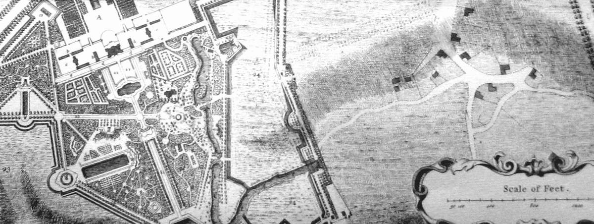
Part of a survey plan published by Sarah Bridgeman in 1739. The village of Lamport is shown, with much artistic licence, east of Stowe House.
Lamport as it appears in a Tithe Apportionment map published in 1850.