Abandoned Communities ..... Temperance Town
Most of the places described in this website were in rural locations or close to the sea. However, there are also many examples of districts within large towns or cities that have been abandoned. They may be less conspicuous today, as the space they occupied has usually been redeveloped for other purposes. But for the people who were forced to move out the process of departing and starting a new life in another home would generally have been no less traumatic.
Temperance Town was an area near the centre of Cardiff built in the 1860s. At that time Cardiff was expanding rapidly as a port specialising in the export of coal. The West Bute dock had opened in 1839, and the East Bute dock in 1855. The main railway line through South Wales to Fishguard had been constructed around 1850. The engineering of the railway line through Cardiff had presented a number of problems, not least the presence of the River Taff. As it approached the sea the Taff passed around several meanders, which had gradually changed their location over the centuries and one of which was creeping closer to the west side of St Mary Street. St Mary’s church itself had yielded to flooding a couple of centuries earlier.
The solution was to cut a new straight channel for the river, with embankments on each side to prevent flooding. A large area of very wet low lying land was left between the new channel and the old one. Part of that area is now occupied by the Millennium Stadium, the main venue for the Rugby World Cup in 1999. The land immediately north of the railway station was, however, the first to be built upon. It was owned by Colonel Edward Wood, but leased to Jacob Mathews.
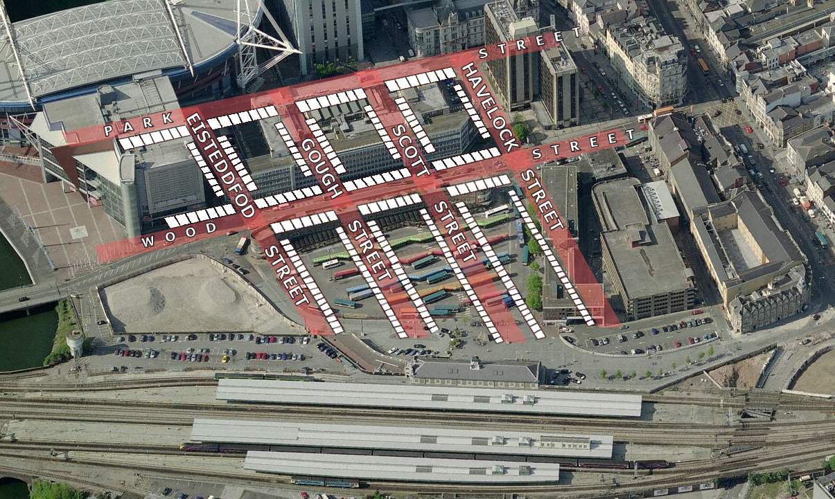
Around 1860 Mathews authorised the tipping of huge quantities of rubbish onto this land, streets were laid out, and very soon a new suburb had been created. The main street running east to west through the area, named Wood Street after the owner of the land, was filled with shops and other businesses, while the remaining streets were predominantly residential. From west to east they were Eisteddfod Street, Gough Street, Scott Street, and Havelock Street. Park Street ran across the northern edge of the district, with houses only on its southern side.
Colonel Wood did not approve of alcohol. In the lease of 1858 he specified that certain trades could not be carried on without his permission, including tavern keeper, alehouse keeper, and retailer of beer. Mathews, himself a teetotaller, was happy to comply with this requirement. I do not know whether the official name of the district was Temperance Town from its beginning, but that is what it soon became called. Processions proclaiming the virtues of abstinence were often seen making their way though the area and into neighbouring streets. The first public building to be erected was a splendid Temperance Hall, on the corner of Wood Street and Havelock Street.
Reminiscences about the entertainment on offer in the early days of the Temperance Hall are recorded in the Western Mail, 5 June 1934. Favourite songs were “Alonzo the Brave and the Fair Imogen”, “The Good St Anthony”, and “Let Me Like a Soldier Fall”. Another song celebrated the escape from Paris in a balloon by the French government minister Léon Gambetta.
The words of Let Me Like a Soldier Fall and a rendering of the second verse can be found on the James Joyce Music website.
Two people living in Temperance Town during the 1870s were David Hutchinson and his son-in-law Joseph Taylor. David Hutchinson and his wife lived at 59 Wood Street, and Joseph Taylor and his family at 40 Scott Street. Under their professional names of Hutchinson and Tayleure they built a large wooden circus in St Mary Street.
The circus opened on 14 November 1870. During the first season performers included De Castro's French Troupe, a group of six male and female acrobats and gymnasts, and Signor Napoli, the Italian Hercules, who was indisputably the strongest man in existence.
I am quoting an advert in the Western Mail on 9 January 1871.
Also taking part was Monsignor Niblo, the renowned trapezist. Niblo suffered an alarming accident on 13 December 1870. Having completed a series of wonderful aerial flights he performed a double somersault and as he landed the stage collapsed beneath him. If it had not been for his cat-like agility he would have been seriously injured. As it was his astonishing escape was loudly cheered from all parts of the circus.
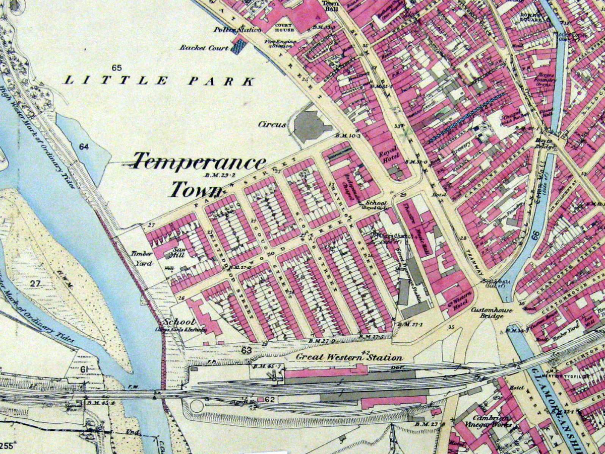
A few years later Hutchinson and Tayleure erected another circus at the north east corner of Temperance Town. The new circus, which opened on 6 November 1876, could hold about 2000 people. You can see it on the map on the left. By this time equestrian events were an especially popular part of the programme. Beneath the circus it was necessary to build stables for about 40 horses.
For more on the history of Cardiff, especially during the Victorian period, go to The Cardiff Story by Dennis Morgan, D Brown & Sons, 1991.
Temperance Town was an area near the centre of Cardiff built in the 1860s. At that time Cardiff was expanding rapidly as a port specialising in the export of coal. The West Bute dock had opened in 1839, and the East Bute dock in 1855. The main railway line through South Wales to Fishguard had been constructed around 1850. The engineering of the railway line through Cardiff had presented a number of problems, not least the presence of the River Taff. As it approached the sea the Taff passed around several meanders, which had gradually changed their location over the centuries and one of which was creeping closer to the west side of St Mary Street. St Mary’s church itself had yielded to flooding a couple of centuries earlier.
The solution was to cut a new straight channel for the river, with embankments on each side to prevent flooding. A large area of very wet low lying land was left between the new channel and the old one. Part of that area is now occupied by the Millennium Stadium, the main venue for the Rugby World Cup in 1999. The land immediately north of the railway station was, however, the first to be built upon. It was owned by Colonel Edward Wood, but leased to Jacob Mathews.
Around 1860 Mathews authorised the tipping of huge quantities of rubbish onto this land, streets were laid out, and very soon a new suburb had been created. The main street running east to west through the area, named Wood Street after the owner of the land, was filled with shops and other businesses, while the remaining streets were predominantly residential. From west to east they were Eisteddfod Street, Gough Street, Scott Street, and Havelock Street. Park Street ran across the northern edge of the district, with houses only on its southern side.
Colonel Wood did not approve of alcohol. In the lease of 1858 he specified that certain trades could not be carried on without his permission, including tavern keeper, alehouse keeper, and retailer of beer. Mathews, himself a teetotaller, was happy to comply with this requirement. I do not know whether the official name of the district was Temperance Town from its beginning, but that is what it soon became called. Processions proclaiming the virtues of abstinence were often seen making their way though the area and into neighbouring streets. The first public building to be erected was a splendid Temperance Hall, on the corner of Wood Street and Havelock Street.
Reminiscences about the entertainment on offer in the early days of the Temperance Hall are recorded in the Western Mail, 5 June 1934. Favourite songs were “Alonzo the Brave and the Fair Imogen”, “The Good St Anthony”, and “Let Me Like a Soldier Fall”. Another song celebrated the escape from Paris in a balloon by the French government minister Léon Gambetta.
The words of Let Me Like a Soldier Fall and a rendering of the second verse can be found on the James Joyce Music website.
Two people living in Temperance Town during the 1870s were David Hutchinson and his son-
The circus opened on 14 November 1870. During the first season performers included De Castro's French Troupe, a group of six male and female acrobats and gymnasts, and Signor Napoli, the Italian Hercules, who was indisputably the strongest man in existence.
I am quoting an advert in the Western Mail on 9 January 1871.
Also taking part was Monsignor Niblo, the renowned trapezist. Niblo suffered an alarming accident on 13 December 1870. Having completed a series of wonderful aerial flights he performed a double somersault and as he landed the stage collapsed beneath him. If it had not been for his cat-
A few years later Hutchinson and Tayleure erected another circus at the north east corner of Temperance Town. The new circus, which opened on 6 November 1876, could hold about 2000 people. You can see it on the map on the left. By this time equestrian events were an especially popular part of the programme. Beneath the circus it was necessary to build stables for about 40 horses.
For more on the history of Cardiff, especially during the Victorian period, go to The Cardiff Story by Dennis Morgan, D Brown & Sons, 1991.
One
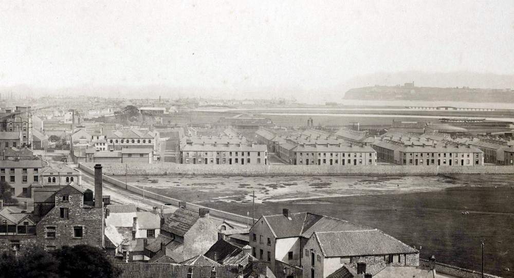
View of Temperance Town from the north
This photograph, taken about 1870, has been supplied by Cardiff Central Library
Ordnance Survey map of 1880, showing Temperance Town and the surrounding area
The streets of Temperance Town superimposed on an aerial view from about 2008.
This image has been created by Matthew Witty of www.cardiffians.co.uk.