Abandoned Communities ..... Rochdale Reservoirs
Several of the valleys north of Rochdale in Greater Manchester have reservoirs. In this section we will take a look at three valleys that once had thriving communities but have become deserted since the construction of their reservoirs.
In the Cowm valley the construction of a reservoir began in 1868 and it opened for use in 1877. The Cowm valley lies just outside the town of Whitworth, about three miles north of Rochdale. Before it was built the Rochdale Corporation had great difficulty meeting the demand for water, both from domestic and industrial consumers. During periods of drought it had sometimes been necessary to use water carts with barrels to maintain basic water supplies.
The census of 1851 recorded that 139 people lived in the valley. They occupied 26 houses and farms, and there was a cotton mill and a stone polishing mill. After the reservoir came into being several houses, including the hamlet of Cowclough, survived as they were above the water line. But gradually they were abandoned. The last few people to live in the Cowm valley left in 1950.
Most of my information about the Cowm valley has come from a delightful booklet by Joan Douglas, Cowm: The Valley that Died, available from the Whitworth Historical Society.
Joan Douglas has used the 1851 census information to present a picture of life in the valley before the reservoir. There were six farmers, and four other men who combined farming with dealing in stone. Another man was a full-time stone dealer. 15 people were employed as quarrymen, and 16 in the cotton mill as frame tenders, power loom weavers, and a creeler. In the earlier part of the nineteenth century several households would have had a hand-loom for weaving woollen cloth, but in 1851, only one man, William Mills, was listed as a woollen weaver, and as he was 76 he may well have retired by then.
There are indications of social differences within the valley. Of two boys aged thirteen John Jackson was still at school. His father, Samuel Jackson, was a farmer and stone dealer owning property at Higher Cowm that included 12 acres of arable land and 100 acres of moorland. The other boy, Richard Holden, was working as a coal miner. His father, John Holden, owned a farm further up the valley at Dules Mouth that had just four acres of arable land and 25 acres of moorland. In the family of blacksmith James Saunderson, who lived at Cowclough, there was no adult woman, but Sarah Saunderson, aged 10, was occupied with domestic duties.
The census information also reveals that not many people lived into old age. Of the 139 people in the valley only six were over 70, and only one of those was over 80.
The cotton mill occupied a site at the northern end of the reservoir. On a map of 1845 a chimney is shown at the mill, evidence that the mill was then using steam power. Lower Cowm Farm was a short distance from the cotton mill. In 1851 27 people in 5 families lived there, presumably providing some of the workers at the mill. Both the mill and Lower Cowm farm were demolished when the reservoir was built.
Most of the quarries were located at the northern end of the valley, and in addition Thurns Head quarry lay on the west side above Cowclough. In the middle of the nineteenth century stone from the northern end of the valley was transported down the valley along a road called Cowclough Lane. The grooves formed in the road surface by the heavily laden carts can still be seen today. One of the quarry workers of that time, later known as Owd Pinder, began work in the quarry at the age of ten, and apparently used to claim that he had already worked for three years in a mill.
In the Cowm valley the construction of a reservoir began in 1868 and it opened for use in 1877. The Cowm valley lies just outside the town of Whitworth, about three miles north of Rochdale. Before it was built the Rochdale Corporation had great difficulty meeting the demand for water, both from domestic and industrial consumers. During periods of drought it had sometimes been necessary to use water carts with barrels to maintain basic water supplies.
The census of 1851 recorded that 139 people lived in the valley. They occupied 26 houses and farms, and there was a cotton mill and a stone polishing mill. After the reservoir came into being several houses, including the hamlet of Cowclough, survived as they were above the water line. But gradually they were abandoned. The last few people to live in the Cowm valley left in 1950.
Most of my information about the Cowm valley has come from a delightful booklet by Joan Douglas, Cowm: The Valley that Died, available from the Whitworth Historical Society.
Joan Douglas has used the 1851 census information to present a picture of life in the valley before the reservoir. There were six farmers, and four other men who combined farming with dealing in stone. Another man was a full-
There are indications of social differences within the valley. Of two boys aged thirteen John Jackson was still at school. His father, Samuel Jackson, was a farmer and stone dealer owning property at Higher Cowm that included 12 acres of arable land and 100 acres of moorland. The other boy, Richard Holden, was working as a coal miner. His father, John Holden, owned a farm further up the valley at Dules Mouth that had just four acres of arable land and 25 acres of moorland. In the family of blacksmith James Saunderson, who lived at Cowclough, there was no adult woman, but Sarah Saunderson, aged 10, was occupied with domestic duties.
The census information also reveals that not many people lived into old age. Of the 139 people in the valley only six were over 70, and only one of those was over 80.
The cotton mill occupied a site at the northern end of the reservoir. On a map of 1845 a chimney is shown at the mill, evidence that the mill was then using steam power. Lower Cowm Farm was a short distance from the cotton mill. In 1851 27 people in 5 families lived there, presumably providing some of the workers at the mill. Both the mill and Lower Cowm farm were demolished when the reservoir was built.
Most of the quarries were located at the northern end of the valley, and in addition Thurns Head quarry lay on the west side above Cowclough. In the middle of the nineteenth century stone from the northern end of the valley was transported down the valley along a road called Cowclough Lane. The grooves formed in the road surface by the heavily laden carts can still be seen today. One of the quarry workers of that time, later known as Owd Pinder, began work in the quarry at the age of ten, and apparently used to claim that he had already worked for three years in a mill.
One
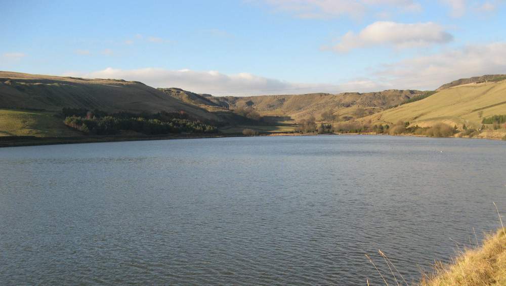
Cowm Reservoir
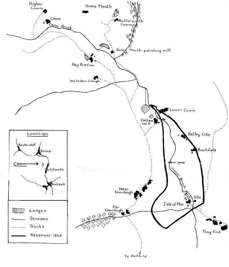
The Cowm valley in 1820, with the later reservoir superimposed.
This map comes from the booklet by Joan Douglas, Cowm: The Valley that Died.
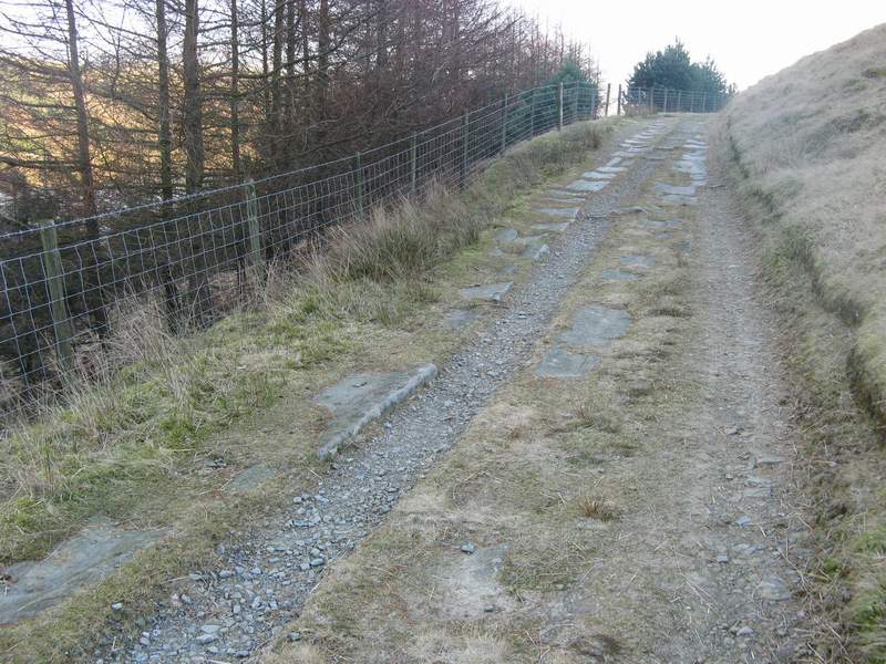
Cowclough Lane
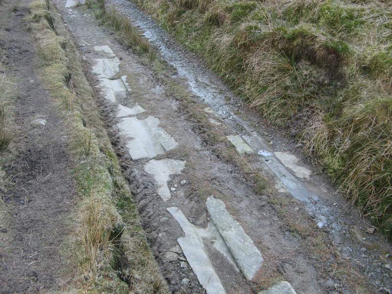
Ruts in the road surface caused by the passage of carts laden with stone