Abandoned Communities ..... Rochdale Reservoirs
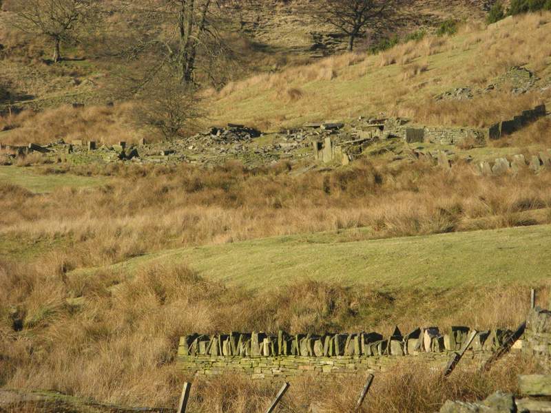
The largest settlement was at Cowclough. On a map of 1820 it is shown in two parts, Near Cowclough and Far Cowclough, but later it was always referred to as a single hamlet. In 1851 52 people lived there in a farmhouse and 10 other households.
If you visit the Cowm valley make sure you climb the side of the valley as far as Cowclough. Take Joan Douglas' booklet with you and see if you can identify some of the buildings and stone features described in it.
Cowclough survived the building of the reservoir, but was eventually deserted in 1928. Various tales have been recorded of people living in Cowclough and visitors to it during the period after the reservoir was opened. One resident was on his way home one night from the Railway in Whitworth (now the Cock and Magpie). As the reservoir was covered with ice he decided to take a short cut across it. The ice started to crack up, but by leaping rapidly over the remaining ice he reached the far bank safely. Apparently he was well know as a clog dancer, and would always change from his heavy working clogs into a lightweight pair before going out for a drink.
Another resident of Cowclough, Owd Mrs Butterfly, used to make butterflies, possibly knitted or crocheted, and take them round in a basket to sell them. Visitors to Cowclough included Donkey Bill, who would come round regularly with a jug of black peas and a basket of tripe, and Squire Clegg, who walked up from Rochdale with articles of haberdashery in a large pack on his back.
At one time a group of Pallottine nuns lived at Cowclough. Joan Douglas was told that the nuns “looked like black penguins as they came down Cock Hall steps on their way to church”. It was said that the nuns sometimes had to resort to begging.
The last people living at Cowclough were Richard Parker and his family. In 1928 they left and went to live at Houses o' th' Hill.
Immediately after the creation of the reservoir a number of new dwellings were erected in the valley. Close to Lower Cowm farm three cottages were built, presumably to house people whose homes had been flooded. Then a farmhouse was built at Back Cowm Farm in 1870. But after World War I the Water Board became concerned about the possibility of pollution of the reservoir by local residents, and embarked on a policy of clearing the valley. Some current residents were allowed to stay, but if they moved out they would not be replaced and their home would fall into ruin.
At Back Cowm Farm the Parker family continued to occupy the farmhouse. In her book Joan Douglas has recorded a lot of the memories of Jesse Parker, born in 1913, including a detailed description of the various rooms in the farmhouse, including a large two roomed cellar that was partly under the ground. Eventually Jesse Parker had to move away in 1950. The very last inhabitants of the Cowm valley also left in that year. They were the Akerigg family of Walsden Clough.
Cowm reservoir itself has not been used to supply water since 1975. Large quantities of used tyres had been dumped in a former quarry at the head of the valley, but in that year they were set on fire. Before long chemicals from the burnt tyres had entered the water of the reservoir. The water was confirmed as unfit to drink, and in any case it was described as tasting like TCP. In the 1980s the reservoir was opened again as a centre for water skiing. In 2009 United Utilities announced that the water quality was satisfactory, but it is unlikely that the reservoir will again be used to supply water as the cost of restoring it to modern standards of operation would be too great.
See the Rochdale Observer for 21 November, 2009.
If you intend to go to Cowm try to plan your visit on a day when the Whitworth Museum is open. The museum, just a short distance from the Cowm valley, is run by the Whitworth Historical Society. On display is a huge and varied collection of objects that give a vivid impression of everyday life in the area when people were still living in the Cowm valley. You may also have a chance to see the 1820 map, an astonishing hand-drawn map that depicts the valley at that time in great detail.
If you visit the Cowm valley make sure you climb the side of the valley as far as Cowclough. Take Joan Douglas' booklet with you and see if you can identify some of the buildings and stone features described in it.
Cowclough survived the building of the reservoir, but was eventually deserted in 1928. Various tales have been recorded of people living in Cowclough and visitors to it during the period after the reservoir was opened. One resident was on his way home one night from the Railway in Whitworth (now the Cock and Magpie). As the reservoir was covered with ice he decided to take a short cut across it. The ice started to crack up, but by leaping rapidly over the remaining ice he reached the far bank safely. Apparently he was well know as a clog dancer, and would always change from his heavy working clogs into a lightweight pair before going out for a drink.
Another resident of Cowclough, Owd Mrs Butterfly, used to make butterflies, possibly knitted or crocheted, and take them round in a basket to sell them. Visitors to Cowclough included Donkey Bill, who would come round regularly with a jug of black peas and a basket of tripe, and Squire Clegg, who walked up from Rochdale with articles of haberdashery in a large pack on his back.
At one time a group of Pallottine nuns lived at Cowclough. Joan Douglas was told that the nuns “looked like black penguins as they came down Cock Hall steps on their way to church”. It was said that the nuns sometimes had to resort to begging.
The last people living at Cowclough were Richard Parker and his family. In 1928 they left and went to live at Houses o' th' Hill.
Immediately after the creation of the reservoir a number of new dwellings were erected in the valley. Close to Lower Cowm farm three cottages were built, presumably to house people whose homes had been flooded. Then a farmhouse was built at Back Cowm Farm in 1870. But after World War I the Water Board became concerned about the possibility of pollution of the reservoir by local residents, and embarked on a policy of clearing the valley. Some current residents were allowed to stay, but if they moved out they would not be replaced and their home would fall into ruin.
At Back Cowm Farm the Parker family continued to occupy the farmhouse. In her book Joan Douglas has recorded a lot of the memories of Jesse Parker, born in 1913, including a detailed description of the various rooms in the farmhouse, including a large two roomed cellar that was partly under the ground. Eventually Jesse Parker had to move away in 1950. The very last inhabitants of the Cowm valley also left in that year. They were the Akerigg family of Walsden Clough.
Cowm reservoir itself has not been used to supply water since 1975. Large quantities of used tyres had been dumped in a former quarry at the head of the valley, but in that year they were set on fire. Before long chemicals from the burnt tyres had entered the water of the reservoir. The water was confirmed as unfit to drink, and in any case it was described as tasting like TCP. In the 1980s the reservoir was opened again as a centre for water skiing. In 2009 United Utilities announced that the water quality was satisfactory, but it is unlikely that the reservoir will again be used to supply water as the cost of restoring it to modern standards of operation would be too great.
See the Rochdale Observer for 21 November, 2009.
If you intend to go to Cowm try to plan your visit on a day when the Whitworth Museum is open. The museum, just a short distance from the Cowm valley, is run by the Whitworth Historical Society. On display is a huge and varied collection of objects that give a vivid impression of everyday life in the area when people were still living in the Cowm valley. You may also have a chance to see the 1820 map, an astonishing hand-
Two
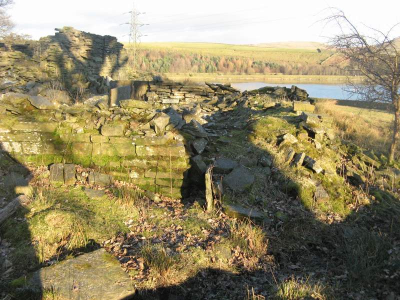
Ruins at Near Cowclough
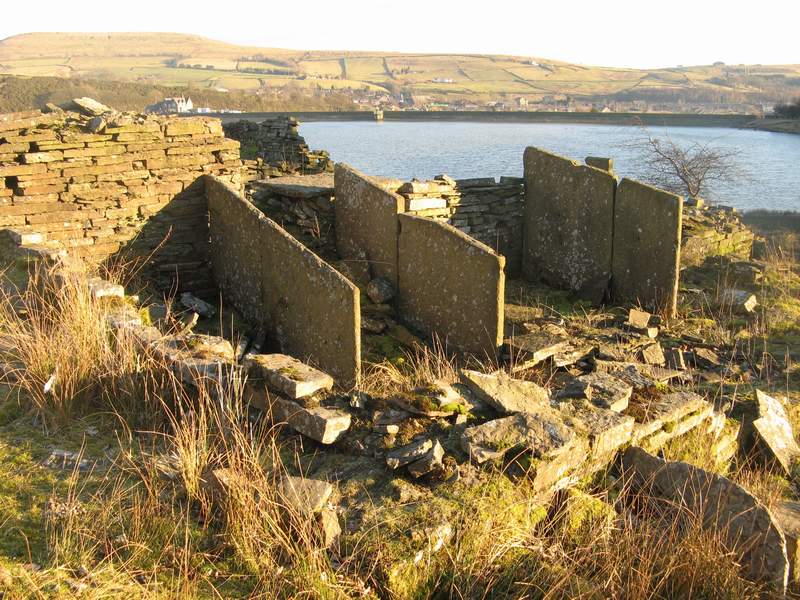
More ruins at Near Cowclough.
According to Andy Read upright stone slabs are common in the area. In this case they probably divided an internal space that may have been roofed with timber. The space would have been used to store fuel or animal food supplies, or as space for farm animals.
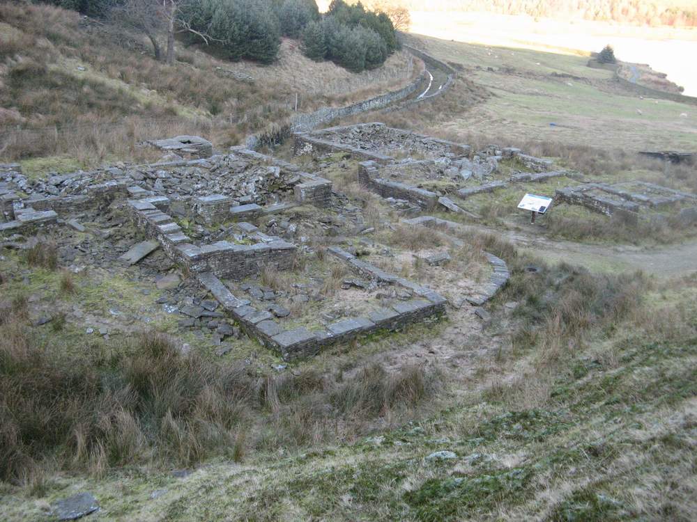
Far Cowclough
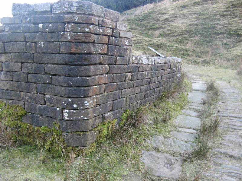
Cowclough Lane as it passes through Far Cowclough. The angled corner on the building would have reduced damage from the impact of passing vehicles.
Back Cowm Farm in January 2011
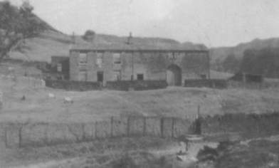
Back Cowm Farm