Abandoned Communities ..... Shifting Sands
We now move west to the mouth of the River Findhorn, on the southern bank of the Moray Firth. Today the area on the west side of the river, Culbin Sands, is managed by the Forestry Commission and is covered with conifer trees. Across the estuary on the east side of the river lies the present village of Findhorn.
Look it up on Google Maps at this address for a magnificent aerial photograph taken at low tide.
We will return in a moment to the story of Findhorn. In the seventeenth century Culbin was a barony owned by the Kinnaird family. It contained a manor house and 16 farms, most of them clustered into three small settlements called Middlebin, Laik, and Delpottie. The relationship between the laird and the people living on the estate, building techniques, and general way of life were probably typical of Highland society before the battle of Culloden in 1746 changed everything.
A brief introduction to the Highland way of life has been given in the section of this website about Strathnaver, at this address; or for an account more specifically related to Culbin read chapters 9 and 10 in Sinclair Ross, The Culbin Sands: Fact and Fiction, Centre for Scottish Studies, Aberdeen University, 1992.
The prosperity of the Culbin estate has become a matter of controversy. For a long time it was thought that the estate was very wealthy, and it attracted the reputation of being the “granary and garden of Moray”. Sinclair Ross’ book, however, has challenged this view. The main evidence supporting the traditional view has come from a document purporting to be a list of the rents on the estate to be paid in 1693. The contents of the document were quoted in a book by Charles Fraser-Mackintosh in 1865. It gave the names of the 16 farmer tenants, together with their annual rents. Some were required to pay £40 in money, others £200, but all 16 owed 40 bolls of wheat, 40 bolls of bear, 40 bolls of oats, and 40 bolls of meal.
Please correct me if I am wrong, but I assume that bear is barley. The title of the book by Fraser-Mackintosh is Antiquarian notes: Historical, Genealogical, and Social.
The original rental document appears to have been lost. Sinclair Ross, apart from expressing surprise that all 16 tenants were required to supply exactly the same amount of the four types of grain, argues that it is inconceivable that the estate would have been capable of producing every year the total amount of money and crops listed in the rental. He suggests that the figures in the 1693 document might refer to the estimated value of the land, rather than the annual rent.
However prosperous the estate may have once been, it was largely overwhelmed by sand in a storm that occurred in 1694. Wind blown sand may have started to encroach several years earlier. It is likely that heather and marram grass from the dunes along the coast were used for thatch, animal bedding, and other purposes, and large quantities of turf would have been cut for use in building and as fuel. In this way areas of sand may have become exposed and then carried inland by high winds. Local people were probably well aware of this danger, and in 1663 Nairn Town Council issued orders banning the cutting of turf close to the sea.
As a result of the storm of 1694 the landowner Alexander Kinnaird claimed that “two parts” of Culbin had been covered by sand. In 1695 he submitted a petition to Parliament requesting “relief from cess”, a reduction in taxation, in view of the damage done to the estate. According to the petition the “best two parts of his estate of Culbin, by an unavoidable fatality, was quite ruined and destroyed, occasioned by great and vast heaps of sand, so that there was not a vestige to be seen of his manor place of Culbin, yards, orchards and mains thereof, and which, within these twenty years, were as considerable as many in the county of Moray; and the small remainder of his estate which yet remained uncovered was exposed to the like hazard, and the sand daily gaining ground thereon.”
It appears that no record has survived of the outcome of Kinnaird’s petition, but one consequence was that in the same year the Scottish Parliament passed an Act forbidding the pulling of bent, broom, or juniper off sand hills, making specific reference to Culbin.
By 1698 Alexander Kinnaird had run into serious financial difficulties, and his creditors were putting pressure on him to settle his debts. He appealed to Parliament again, this time seeking protection from his creditors. He claimed that by now sand had been blown over three quarters of his lands. The requested protection was granted on the grounds that his debts were largely the result of an act of God.
There are differing reports of what happened to Alexander Kinnaird after 1698. According to one account he took part in the Darien scheme, the attempt by emigrants from Scotland to set up a trading colony in central America, and was one of hundreds who died when the scheme went badly wrong in 1700.
Look it up on Google Maps at this address for a magnificent aerial photograph taken at low tide.
We will return in a moment to the story of Findhorn. In the seventeenth century Culbin was a barony owned by the Kinnaird family. It contained a manor house and 16 farms, most of them clustered into three small settlements called Middlebin, Laik, and Delpottie. The relationship between the laird and the people living on the estate, building techniques, and general way of life were probably typical of Highland society before the battle of Culloden in 1746 changed everything.
A brief introduction to the Highland way of life has been given in the section of this website about Strathnaver, at this address; or for an account more specifically related to Culbin read chapters 9 and 10 in Sinclair Ross, The Culbin Sands: Fact and Fiction, Centre for Scottish Studies, Aberdeen University, 1992.
The prosperity of the Culbin estate has become a matter of controversy. For a long time it was thought that the estate was very wealthy, and it attracted the reputation of being the “granary and garden of Moray”. Sinclair Ross’ book, however, has challenged this view. The main evidence supporting the traditional view has come from a document purporting to be a list of the rents on the estate to be paid in 1693. The contents of the document were quoted in a book by Charles Fraser-
Please correct me if I am wrong, but I assume that bear is barley. The title of the book by Fraser-
The original rental document appears to have been lost. Sinclair Ross, apart from expressing surprise that all 16 tenants were required to supply exactly the same amount of the four types of grain, argues that it is inconceivable that the estate would have been capable of producing every year the total amount of money and crops listed in the rental. He suggests that the figures in the 1693 document might refer to the estimated value of the land, rather than the annual rent.
However prosperous the estate may have once been, it was largely overwhelmed by sand in a storm that occurred in 1694. Wind blown sand may have started to encroach several years earlier. It is likely that heather and marram grass from the dunes along the coast were used for thatch, animal bedding, and other purposes, and large quantities of turf would have been cut for use in building and as fuel. In this way areas of sand may have become exposed and then carried inland by high winds. Local people were probably well aware of this danger, and in 1663 Nairn Town Council issued orders banning the cutting of turf close to the sea.
As a result of the storm of 1694 the landowner Alexander Kinnaird claimed that “two parts” of Culbin had been covered by sand. In 1695 he submitted a petition to Parliament requesting “relief from cess”, a reduction in taxation, in view of the damage done to the estate. According to the petition the “best two parts of his estate of Culbin, by an unavoidable fatality, was quite ruined and destroyed, occasioned by great and vast heaps of sand, so that there was not a vestige to be seen of his manor place of Culbin, yards, orchards and mains thereof, and which, within these twenty years, were as considerable as many in the county of Moray; and the small remainder of his estate which yet remained uncovered was exposed to the like hazard, and the sand daily gaining ground thereon.”
It appears that no record has survived of the outcome of Kinnaird’s petition, but one consequence was that in the same year the Scottish Parliament passed an Act forbidding the pulling of bent, broom, or juniper off sand hills, making specific reference to Culbin.
By 1698 Alexander Kinnaird had run into serious financial difficulties, and his creditors were putting pressure on him to settle his debts. He appealed to Parliament again, this time seeking protection from his creditors. He claimed that by now sand had been blown over three quarters of his lands. The requested protection was granted on the grounds that his debts were largely the result of an act of God.
There are differing reports of what happened to Alexander Kinnaird after 1698. According to one account he took part in the Darien scheme, the attempt by emigrants from Scotland to set up a trading colony in central America, and was one of hundreds who died when the scheme went badly wrong in 1700.
Five
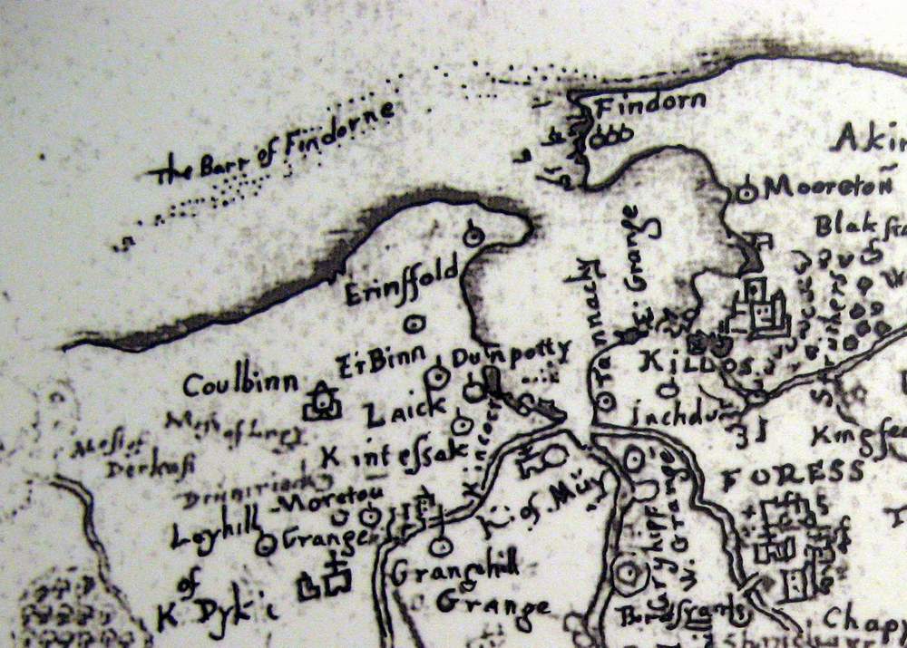
Part of Timothy Pont’s map of 1590, showing Culbin and the bay of Findhorn. It also shows the bar of Findhorn.
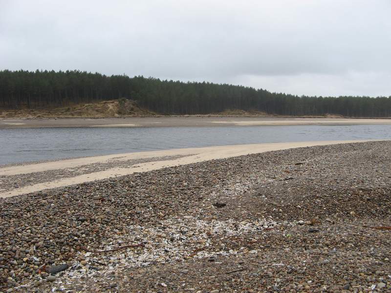
View of Culbin sands, taken from across the river on the present shingle spit at the mouth of the river.
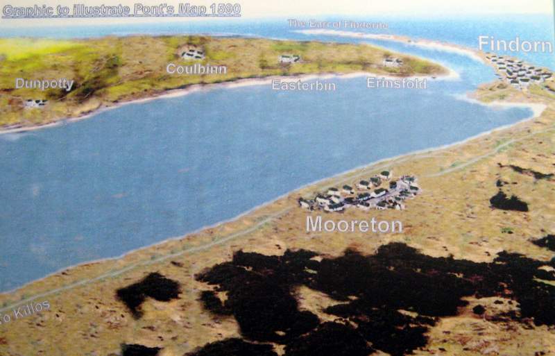
A seagull’s view of Culbin and Findhorn Bay, done by Lambert Munro and based on Pont’s map.