Abandoned Communities ..... Norfolk
In December 2007 there was an e-mail from Patricia Collins saying she could see the site of the deserted medieval village of Grenstein from her kitchen window. Early in June 2009 I got round to visiting Grenstein, and on the same trip I went to see Godwick, a mile or so to the north.
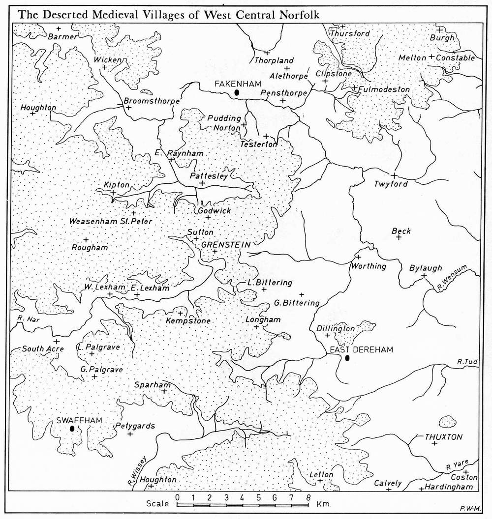
Grenstein and Godwick were two small villages in central Norfolk, roughly midway between Kings Lynn and Norwich. Grenstein lay at OS TF906198 and Godwick at OS TF903220. This part of Norfolk has many deserted and shrunken medieval villages, as you can see from the map on the left.
On the same trip I also went to Rougham. Rougham was a larger village and some of its earthworks can still be seen. It has a fascinating history with a wealth of intriguing documentary evidence. But apart from this brief mention it will not be described in this website as a small part of Rougham still exists. It is a shrunken village rather than a completely abandoned community.
If you want to know more about Rougham there is an excellent article by Alan Davison and other authors in East Anglian Archaeology, 1988, Report no. 44, 48-70.
Grenstein lay on an exposed hillside facing south. Its main street, which ran down the gentle slope of the hill, formed part of the road between Mileham and Tittleshall. The site of the village was bulldozed in 1959 and subsequently has been regularly ploughed. The fields are now used for growing crops or hay. The plan of the village does, however, appear fairly clearly on old aerial photographs. Other information about Grenstein has come from a certain amount of rather confusing documentary evidence. But most of our knowledge of the village has been gained from archaeological excavations carried out under the direction of Peter Wade-Martins in 1965 and 1966.
This work was reported in a long and detailed article by Peter Wade-Martins and his colleagues in East Anglian Archaeology, 1980, Report no. 10, 93-168.
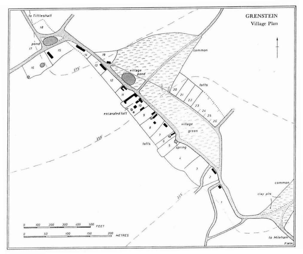
A few sherds of Late Saxon pottery were found on the surface close to the crossroads at the northern end of the village. They suggest that some kind of settlement, a single farm or perhaps a small hamlet, existed there before the Norman Conquest. But the main development of Grenstein, then known as Greynston, took place during the twelfth century. A village green was created beside the main street, and farmsteads were laid out along both sides of the green. The majority of these tofts were located on the western side of the green, but there were about seven on the eastern side.
As you can see from the reconstructed village plan there were two ponds, the main one located near the top of the green. There was a spring at the front of toft 5, and several tofts had pits that were probably used to hold water. There was no church. A manor house, Greynston Manor, was probably located in an area now known as Lounds Wood, approached along the road leading west from the crossroads at the head of the village.
In 1251 Ranulph le Cunte and his wife Joan were given permission to hold a market at Greynston every Wednesday and an annual fair from 19 to 21 July. The same charter gave them the right to free warren on the demesne lands of Greynston and Tittleshall, the right to catch rabbits on land directly managed by the lord of the manor.
Grenstein and Godwick were two small villages in central Norfolk, roughly midway between Kings Lynn and Norwich. Grenstein lay at OS TF906198 and Godwick at OS TF903220. This part of Norfolk has many deserted and shrunken medieval villages, as you can see from the map on the left.
On the same trip I also went to Rougham. Rougham was a larger village and some of its earthworks can still be seen. It has a fascinating history with a wealth of intriguing documentary evidence. But apart from this brief mention it will not be described in this website as a small part of Rougham still exists. It is a shrunken village rather than a completely abandoned community.
If you want to know more about Rougham there is an excellent article by Alan Davison and other authors in East Anglian Archaeology, 1988, Report no. 44, 48-
Grenstein lay on an exposed hillside facing south. Its main street, which ran down the gentle slope of the hill, formed part of the road between Mileham and Tittleshall. The site of the village was bulldozed in 1959 and subsequently has been regularly ploughed. The fields are now used for growing crops or hay. The plan of the village does, however, appear fairly clearly on old aerial photographs. Other information about Grenstein has come from a certain amount of rather confusing documentary evidence. But most of our knowledge of the village has been gained from archaeological excavations carried out under the direction of Peter Wade-
This work was reported in a long and detailed article by Peter Wade-
A few sherds of Late Saxon pottery were found on the surface close to the crossroads at the northern end of the village. They suggest that some kind of settlement, a single farm or perhaps a small hamlet, existed there before the Norman Conquest. But the main development of Grenstein, then known as Greynston, took place during the twelfth century. A village green was created beside the main street, and farmsteads were laid out along both sides of the green. The majority of these tofts were located on the western side of the green, but there were about seven on the eastern side.
As you can see from the reconstructed village plan there were two ponds, the main one located near the top of the green. There was a spring at the front of toft 5, and several tofts had pits that were probably used to hold water. There was no church. A manor house, Greynston Manor, was probably located in an area now known as Lounds Wood, approached along the road leading west from the crossroads at the head of the village.
In 1251 Ranulph le Cunte and his wife Joan were given permission to hold a market at Greynston every Wednesday and an annual fair from 19 to 21 July. The same charter gave them the right to free warren on the demesne lands of Greynston and Tittleshall, the right to catch rabbits on land directly managed by the lord of the manor.
One
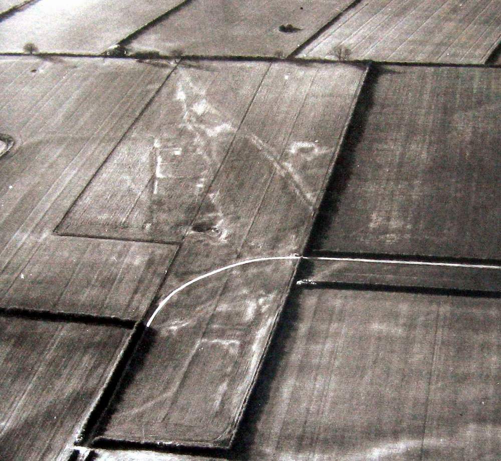
Aerial photograph of Grenstein, taken around 1960 soon after the site was ploughed
Plan of the village
Deserted Medieval Villages of North West Norfolk