Abandoned Communities ..... Norfolk
Detailed information about each toft is given in the report by Peter Wade-Martins. The objectives of the excavations were to examine a section across the main street, to examine the shape and depth of the village pond, and to investigate tofts 9 and 10 as thoroughly as possible. Wet weather in 1966 meant that toft 9 was only partially excavated, but the other objectives were achieved.
The point on the main street chosen for excavation was near its northern end in front of toft 14. The surface of the road was made of flints, and in it two cart ruts were found, about 1.5 metres apart. These ruts may, however, have been formed after the desertion of the village as the road continued in use as the main route between Mileham and Tittleshall. At a lower level a second set of cart ruts were found, with deep grooves in the natural clay below the street. These were assumed to have been formed by medieval carts. On the west side of the road there was a ditch that probably ran down the slope along the front of the western tofts.
Investigation of the pond revealed that its floor had a gentle slope away from the main street. The slope would have allowed access to the pond whatever the level of the water. On its far side the pond had been cut to a depth 1.8 metres below the original ground surface. Only one object, a thirteenth century twisted handle, was found in the pond, evidence that in order to keep the water clean the people of Grenstein had been careful not to throw rubbish into it. The fact that there was a gradual and even silting of the pond was taken as an indication that the pond was never cleared out.
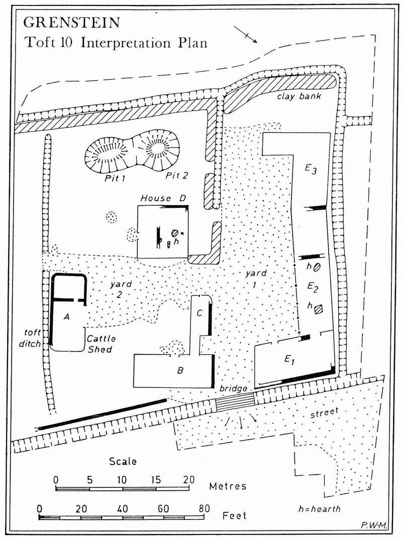
Excavation of toft 10 and the area surrounding it uncovered another street leading away from the main street in a north easterly direction. Toft 10 was 43 metres wide, and 46 metres long from the street ditch to the ditch that marked the rear boundary. The entrance to the toft would have been across a bridge over the street ditch. It led into one of two farmyards. About a quarter of the toft was occupied by a space assumed to be the living area. Within the living area was a dwelling, building D, and two pits. Several other buildings were found in the farmyards. Building A in the more southerly farmyard may have been a cattle shed as it had a wide doorway. Between that building and the front of the toft an area with no special features may have been a stackyard.
Next to building A a track led over the toft boundary ditch into the adjacent toft 9, which appears to have become uninhabited before toft 10. Peter Wade-Martins has suggested that at a late stage, when the village was declining, the vacant toft 9 may have been taken over by the occupants of toft 10 and turned into a paddock.
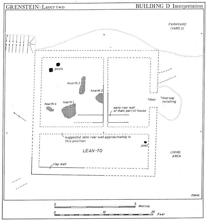
Building D was almost certainly the main farmhouse. It had two rooms at the front, one of them containing the remnants of four hearths.
No cess pits were found within the living area, presumably indicating that domestic waste was taken out with the farm manure and spread on the land. One of the two pits was originally 1.5 metres deep, and as it contained very few finds it was interpreted by Wade-Martins as a water tank. The base of a large jug was found near the bottom of this pit. It may have been used to scoop water out. The other pit held a layer of rubbish, including a great deal of pottery, sea shells, and charcoal. 651 sherds of pottery were found in it. None of the pottery is earlier than the fourteenth century, and we can therefore assume that it comes from the last phase of occupation.
The point on the main street chosen for excavation was near its northern end in front of toft 14. The surface of the road was made of flints, and in it two cart ruts were found, about 1.5 metres apart. These ruts may, however, have been formed after the desertion of the village as the road continued in use as the main route between Mileham and Tittleshall. At a lower level a second set of cart ruts were found, with deep grooves in the natural clay below the street. These were assumed to have been formed by medieval carts. On the west side of the road there was a ditch that probably ran down the slope along the front of the western tofts.
Investigation of the pond revealed that its floor had a gentle slope away from the main street. The slope would have allowed access to the pond whatever the level of the water. On its far side the pond had been cut to a depth 1.8 metres below the original ground surface. Only one object, a thirteenth century twisted handle, was found in the pond, evidence that in order to keep the water clean the people of Grenstein had been careful not to throw rubbish into it. The fact that there was a gradual and even silting of the pond was taken as an indication that the pond was never cleared out.
Excavation of toft 10 and the area surrounding it uncovered another street leading away from the main street in a north easterly direction. Toft 10 was 43 metres wide, and 46 metres long from the street ditch to the ditch that marked the rear boundary. The entrance to the toft would have been across a bridge over the street ditch. It led into one of two farmyards. About a quarter of the toft was occupied by a space assumed to be the living area. Within the living area was a dwelling, building D, and two pits. Several other buildings were found in the farmyards. Building A in the more southerly farmyard may have been a cattle shed as it had a wide doorway. Between that building and the front of the toft an area with no special features may have been a stackyard.
Next to building A a track led over the toft boundary ditch into the adjacent toft 9, which appears to have become uninhabited before toft 10. Peter Wade-
Building D was almost certainly the main farmhouse. It had two rooms at the front, one of them containing the remnants of four hearths.
No cess pits were found within the living area, presumably indicating that domestic waste was taken out with the farm manure and spread on the land. One of the two pits was originally 1.5 metres deep, and as it contained very few finds it was interpreted by Wade-
Two
Toft 10
The house in toft 10